


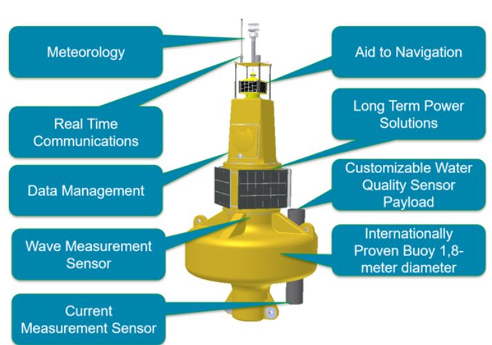
– Marine buoys are specialized, durable (up to 20 years), meeting the standards of prestigious international marine and marine environmental organizations. The buoy integrates self-powered equipment for operation, processing and analysis equipment, real-time information transmission equipment, marine signaling equipment, buoy status and position notification equipment, and modern sensors to measure marine meteorological, hydrogeological and environmental quality indicators, etc. The proposed technical design and construction of buoy bracing depends on the depth and characteristics. The specific point of the monitoring point helps the buoy to withstand storms > level 12.
- Operation:
– The marine meteorological data, oceanographic data and water quality indicators are automatically transmitted to the data management and distribution center via GSM/GPS (Global System for Mobile communication) or satellite transmission. pure. The data is managed, stored securely on the servers of the Ministries and Localities, and displayed in real time and statistics through dedicated software Aanderaa GeoView. The functional units, which have been granted access rights, will access the data easily through the internet.
Status – the position of the buoy is continuously monitored through global positioning, helping to prevent and reduce the risks of vandalism and theft.
With the point of view of proposing investment to integrate as much as possible between the fields to increase the economic – technical efficiency of environmental and resource monitoring activities. Besides, sea buoy is an open system, the selected monitoring parameters change depending on the specific requirements of each locality, each monitoring point, the upgrade and expansion with other monitoring parameters. easily done. Specifically, the monitoring parameters include:
+ Measurement of meteorological parameters including: wind (wind speed, wind direction), air temperature, humidity, atmospheric pressure, solar radiation.
+ Observation of hydrographic parameters: current (flow profile in deep layers), wave (wave height, wave period and wave direction);
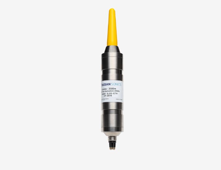
+ Continuous monitoring and monitoring of water quality indicators, including: temperature, conductivity (EC), salinity, turbidity, dissolved oxygen (DO), total amount of algae and blue-green algae (chlorphyll) & blue green alage), fDOM/ CDOM (Fluorescent Dissolved Organic Matter, ratio to Total Dissolved Organic Matter (TOC) parameter), this parameter helps to continuously monitor the discharge of polluted water (if any) into the river/sea), total dissolved solids (TDS)
- System Configuration:
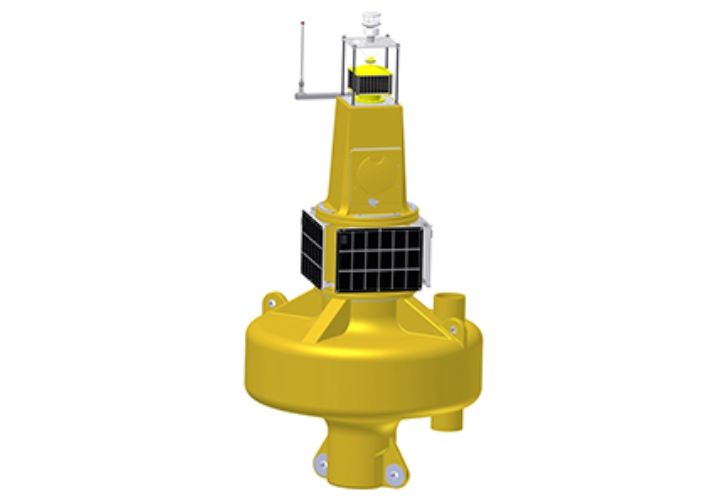
– Buoy body: rotated to create a seamless body without welding, made of 9.5 mm thick UV-stabilized polyethylene. The inner frame structure and anchor eyes are made of stainless steel specifically for the marine environment, creating a system of shockproof, anti-corrosion equipment that can withstand strong impacts and harsh conditions of the sea environment.
The technical setup Buoy
High stability of the buoy in wave and wind conditions is achieved by the center of gravity ballast inside the bottom of the buoy. This ballast set is made by pouring a calculated amount of reinforced concrete into the float, then the whole float is filled with polystyrene beads, then sealed, annealed in a boiler so that the polystyrene particles expand. to its maximum size and flow out. This process creates a solid mass of polystyrene that fills the entire void in the buoy, preventing water from entering even in the event that the buoy is punctured by a strong collision with a vessel. The buoy has a buoyancy of 636 kg and a life expectancy of up to 20 years.
– Power source: the system is configured with 12V or 24V backup power, powered by solar battery modules, the maximum electrical capacity reaches 70 Wp. All electrical – electronic, connection – signal processing equipment is designed to be placed inside the upper part of the float, in waterproof protective boxes Power: the system is configured with 12V or 24V, powered by solar cell modules, the maximum electrical capacity reaches 70 Wp. All electrical – electronic, connection – signal processing equipment is designed to be placed inside the upper part of the buoy, in waterproof protective boxes.
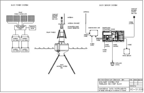
Connector diagram
– Protocol to connect the sensor:
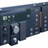
Measurement signals from all sensors are stored, processed and transmitted through a smart data logger (SmartGuard data logger). The intelligent data collector is capable of connecting over 40 measuring sensors with different output signal standards, including: 20 standard AiCaP signal sensors; 10 standard sensor signal standard SR10/VR22; 6 standard analog sensors; 5 standard sensor serial signal; 4 standard digital signal sensors
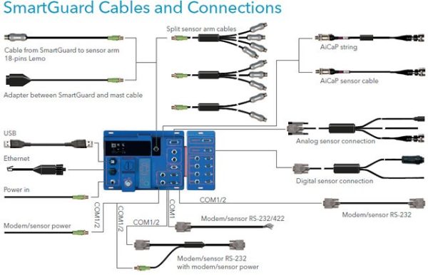
Diagram of the ability to connect, store, process and transmit data from the measuring sensors of the marine buoy
+ Function control power supply for each sensor.
+ Communication interface: USB, Ethernet and serial.
+ Internal memory with large storage capacity: 2 GB.
+ Data transmission method options: Ethernet, radio (UHF and VHF), GPRS, satellite.
– Software to display and analyze marine meteorological data, oceanography and water quality indicators (VnEmisoft):
The software that displays and analyzes marine meteorological data, oceanographic data and water quality indicators is an important component in the entire technical solution for real-time online data transmission of marine buoy stations. Data acquisition and management software works on MicroSoft SQL Database running on a Windows Server (server) located at the station. All data from the buoy is transmitted, stored at the server, and allowed to be displayed and downloaded to a client (licensed) located anywhere there is an internet connection or GPRS (mobile network). . The client can be a computer, ipad, smart phone, etc. with VnEmisoft software installed.
– The basic functions of the software:
1. Web-based format that allows accessing and displaying real-time data using a web browser;
2. Data is automatically updated continuously;
3. Using HTML5/JavaScript structured language that allows displaying data in the form of: statistical graphs in the form of lines (lines), columns (bars), charts showing direction, tables of data,…;
4. Display graphs, graphs of both real-time and historical data (process);
5. The function allows adjusting the time scale, focusing on reviewing any subset of data;
6. Statistical analysis functions such as: mean, maximum, minimum, total, standard deviation,…;
7. Ability to display data of multiple buoy stations at the same time;
8. Access management function, protect data by password (password).

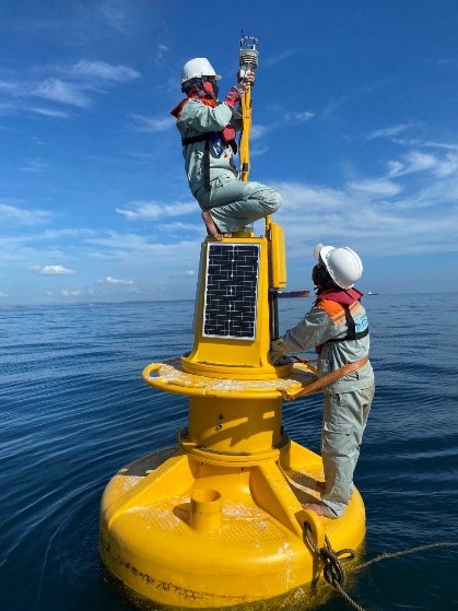
Review The Buoy for meteorological, hydrographic and water quality monitoring
There are no reviews yet.