SkyVue PRO LIDAR Ceilometer

10 km Ceiling LIDAR Ceilometer Cloud measurement with advanced signal processing

The SkyVue™PRO LIDAR Ceilometer measures cloud height and vertical visibility for meteorological and aviation applications and is ideal for long-term research applications where a high level of detail is required. 

Its robust construction is ideal for long-term installation, as it requires minimal maintenance and features a unique stratocumulus calibration procedure—allowing the ceilometer to be calibrated in the field. 

The SkyVue PRO complies with CAA, WMO, and ICAO guidance and meets or exceeds all recommendations and specifications, including CAP437, CAP670, and CAP746. 

With an operational reporting range of 10 km, the SkyVue PRO is easy to use yet boasts advanced signal processing and unique optical arrangements to provide superior resolution and performance. 

The SkyVue PRO has many standard features, from a tilting base and two-axis inclinometer for automatic correction of cloud heights to heaters, blowers, and a sun filter for operation under all conditions—making deployments possible around the world. 

Unique standard features include an easy-to-operate stratocumulus calibration, long-life back-up battery, and twin clocks to augment its many continuous diagnostic self-checks and provide assurance of continuous, reliable, and accurate performance. 

Category:

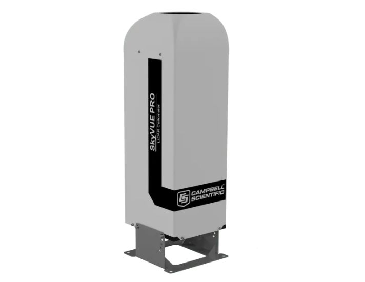
The SkyVue PRO LIDAR ceilometer measures cloud height and vertical visibility for meteorological and aviation applications or long-term research applications where a high level of detail is required. Using LIDAR (LIght Detection And Ranging) technology, the instrument transmits fast, low-power laser pulses into the atmosphere and detects backscattered returns from clouds and aerosols above the instrument. 

A unique, efficient single-lens design increases optical signal-to-noise ratio and allows for larger optics in a compact package, improving accuracy and measurement performance. The optics are immune to damage from direct sunlight. 

This approach, along with state-of-the-art electronics, provides a powerful and stable platform from which to measure cloud height and vertical visibility to high accuracy. The SkyVue PRO measures the atmosphere with high stability and repeatability, delivering excellent performance in even the harshest of conditions. 

The SkyVue PRO provides information on cloud height, sky condition (up to five layers), vertical visibility, and raw backscatter profiles to a range of 10 km. 

An automated Mixing Layer Height (MLH) option is available for air-quality applications. MLH is an important parameter in modelling air quality and air pollution episodes. The MLH is determined based on the operational algorithm used by KNMI, which detects the top of boundary layers. 

The algorithm runs within the SkyVue PRO itself, and the results are incorporated in data messages, making it easy to incorporate the MLH into whatever systems are already in use without the need to run external special software. If you require the MLH option, please contact us. 

The unique stratocumulus calibration capability, which allows users to calibrate measurements of scatter coefficients, uses a simple and user-friendly field method, giving complete confidence in the scatter profiles reported and removes the requirement to have the unit sent back for calibration. 


Reliable range measurement is further assured by cross-checking two separate internal quartz clocks, eliminating the possibility of unidentified errors due to clock drift. 

The SkyVue PRO can be tilted at various angles up to 24°. A small tilt is important, as it allows the ceilometer to resist high levels of reflection from large raindrops and frozen particles that can impair vertical-type sensors. The tilt also improves rain run-off on the ceilometer window, resulting in a much higher performance compared with vertical ceilometers. 

Tilting to 24° also means that it can be operated anywhere in the world without the sun shining into the lens and resulting in missing data. An internal two-axis inclinometer provides automatic correction of cloud height at all angles, ensuring ease of installation and confidence that cloud heights are automatically corrected throughout the lifetime of the installation.  

Software for data visualization and interpretation 

Ceilometer data can be displayed using Campbell’s Viewpoint software or fed directly into existing data systems. The Campbell Viewpoint software will display the output from the ceilometer in a convenient and configurable form, including information on sky condition, mixing layers, and scatter profiles. All can be displayed simultaneously or separately with ranges and time scales. 

Benefits and Features

    • Single-lens design for high signal-to-noise ratio and maximized detector sensitivity, resulting in greater performance at low and high altitudes
    • High performance and high specification at a competitive price
    • Tilt angles to 24°, improving performance during precipitation events and reducing impact of solar glare
    • Unique continuous comparison of two separate internal quartz clocks to ensure measurement confidence
    • Mixing layer height assessment option for air-quality applications
    • User-friendly stratocumulus calibration capability and easy test with a calibrator plate provided as standard for easy field calibration
Dimensions 100 x 32.7 x 28.1 cm (39.4 x 12.9 x 11.1 in.) including base
Shipping Dimensions 120 x 45.0 x 45.0 cm (47.2 x 17.7 x 17.7 in.)
Weight 32 kg (71 lb) without cables
Shipping Weight 58 kg (127.9 lb)
Instrument Performance
Reporting Range 0 to 10 km (0 to 33,000 ft)
Minimum Reporting Resolution 5 m (16.4 ft)
Hard Target Range Accuracy ±0.25%, ±4.6 m (15.1 ft)
Reporting Cycle 2 to 600 s
Cloud Layers Reported Up to four layers
Sky Condition Up to five layers with cover in oktas according to WMO requirements for SYNOP and METAR codes as standard
Vertical Visibility Reported when no clouds selected
Laser Wavelength 912 nm (±5 nm)
Eye Safety Standard Class 1M
Electrical Specification
Power Source 110, 115, 230 Vac ±10%, 50 to 60 Hz, 470 W maximum
Battery Internal 12 Vdc, 2 Ah battery backup

Provides 2 h measurement, without blower/heater, in the event of mains failure.

Interfaces
  • Data – RS-232 / RS-422 / RS-485 / Ethernet
  • Maintenance – USB 2.0 (USB 1.1 compatible)
  • Baud Rate – 300 to 115200 bps
Laser Safety Compliance EN60825-1:2001
Electrical Safety Compliance EN61010-1
Environmental Specification
Temperature Range
  • -40° to +60°C (-40° to +140°F) excluding battery
  • -20° to +50°C (-4° to +122°F) with standard battery
Humidity Range 0 to 100% RH
Maximum Wind Speed 55 m/s (123 mph)
IP Rating IP66 (NEMA 4x)

Brochures: SkyVue™PRO LIDAR Ceilometer

Download

Manuals: SkyVUE™PRO LIDAR Ceilometer

Download

Product reviews

Review SkyVue PRO LIDAR Ceilometer

5 0% | 0 review
4 0% | 0 review
3 0% | 0 review
2 0% | 0 review
1 0% | 0 review
Review SkyVue PRO LIDAR Ceilometer
Choose a image
0 character ( Minimum of 10)
    +

    There are no reviews yet.

    No comments yet

    Related products

    Bộ thu thập và xử lý dữ liệu Granite 10

    Granite 10 Measurement and Control Data-Acquisition System

    Ideal for automotive testing applications, featuring CAN bus and CAN FD output
    Find out more
    Mô-đun Đầu vào Cổng Dòng điện 100 Ohm CURS100

    CURS100 100-Ohm Current Terminal Input Module

    Expands capabilities, allows data logger to measure additional types of sensors
    Find out more
    Datalogger ba kênh cho cảm biến dây rung CRVW3-NE

    CRVW3-NE Three-Channel Vibrating Wire Datalogger without Enclosure

    Vibrating Wire Data Logger Using patented VSPECT™ technology
    Find out more
    Bộ Ghi Dữ Liệu Dây Rung Ba Kênh CRVW3

    CRVW3 Three-Channel Vibrating Wire Datalogger

    Self-Contained Vibrating Wire Data Logger Using patented VSPECT® technology
    Find out more
    Bộ ghi đo tự động Datalogger CR6

    CR6 Automated Monitoring Platform

    Rugged, wireless edge device and gateway with built-in connectivity, designed for geotechnical, structural, and environmental projects
    Find out more
    Bộ ghi dữ liệu đo lường và điều khiển CR350

    CR350 Measurement and Control Datalogger

    Compact data logger with RS-485, ideal for small applications
    Find out more
    Bộ ghi dữ liệu đo lường và điều khiển CR310

    CR310 Measurement and Control Datalogger

    Compact data logger with ethernet, ideal for small applications
    Find out more
    Bộ ghi dữ liệu đo lường và điều khiển CR300

    CR300 Measurement and Control Datalogger

    Compact data logger, ideal for small applications
    Find out more

    Subscribe to Content

    If you need to copy the content, please leave your information, and we will respond as soon as possible. Sincerely, thank you!