Contents of the hydro-meteorological database

Hydrology is a scientific field that studies water and water environments. It focuses on collecting, analyzing, and predicting information related to water, including groundwater, seawater, lakes, rivers, and other water flows. Hydro-meteorological data consists of information and statistics related to water environments collected from monitoring stations and other sources. So what does hydro-meteorological data include? How many types of hydrological data are there? Let’s explore in the following article with Reecotech company.

Contents of the hydro-meteorological database

What is hydrology? The importance of hydrology

Hydrology is the study of water and water environments, focusing on collecting, processing, analyzing, and predicting data related to various types of water, including seawater, groundwater, surface freshwater, and water in the atmosphere. Its significance extends beyond understanding and managing water resources, encompassing flood forecasting, water environment protection, and support for activities such as maritime and aviation transportation.

The importance of hydrology is evident in the following aspects:

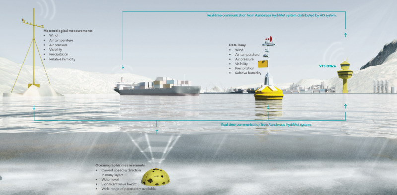
  • Hydrological measurements: Collecting data on sea level, river flow rates, wind speeds, water temperature, and other atmospheric factors. Hydrological measuring devices include flood alarms, tide gauges, and meteorological and hydrological sensors.
  • Weather and flood forecasting: Hydrology plays a crucial role in weather forecasting, tracking low and high-pressure systems, and predicting floods to alert communities and local authorities.
  • Water resource management: Hydrology helps monitor and manage water sources, including groundwater, surface water, and other water resources, to ensure sustainable and efficient use.
  • Water environment protection: Hydrology monitors changes in water environments, detects fluctuations in water quality, and supports the protection of aquatic ecosystems.
  • Support for maritime and aviation transportation: Hydrology provides information on sea conditions and weather, aiding navigation and ensuring safety for ships and aircraft.

Nghành khí tượng thủy văn

5 types of hydrological data

  1. Depth Data: Depth data represents the underwater depth of oceans or lake bottoms. This information is collected and used to create ocean charts, an essential factor for ensuring the safety of vessels navigating the seas or serving other underwater construction projects.
  2. Tidal Data: Tidal data includes information about changes in sea level, from high to low tides. This type of hydrological data plays a crucial role in managing coastal areas, assessing flood risks, and guiding the navigation of watercraft according to tidal cycles. Additionally, this information is used to control structures such as dams, manage water discharge to prevent flood risks and drought.
  3. Flow Data: Flow data provides information about the direction and speed of water movement. This information is applied in activities such as watercraft navigation, search and rescue operations, and environmental research. It is also used to assess the impact of water flow, identifying areas at risk of erosion or sedimentation. Moreover, in some cases, this data is used for designing foundations for underwater construction projects.
  4. Seabed Sediment Data: Data on the characteristics and composition of the seabed is a type of hydrological data that provides vital information for mapping marine environments, dredging activities, and planning the construction of pipelines, cables, as well as structures like piling and foundation construction at sea.
  5. Water Column Data: Water column data contains information about the physical and chemical properties of the water layer, including temperature, salinity, and sound velocity. This type of hydrological data plays a crucial role in oceanography, climate research, and studies of marine life.

Reecotech cung cấp giải pháp quan trắc khí tượng thủy văn

Hydrological data not only serves for creating nautical charts but also plays a significant role in various other applications such as port and harbor maintenance (through dredging activities), coastal engineering (by researching and adjusting beach nourishment and erosion), coastal zone management, offshore resource development, pollution control, offshore energy, and other maritime sectors. Additionally, hydrological data also plays a crucial role in geographic spatial analysis.

In conclusion, hydrological data plays an undeniable role in understanding marine environments and ensuring safety and efficiency in maritime activities. With technological advancements, these pieces of information will increasingly have more potential applications in the future.

Evaluate

Other news

Reecotech Enhances Technician Capabilities with an In-depth ROV Robot Training Course

15/07/2024

Advanced training in the operation and maintenance of Hydro-bios Niskin water samplers

15/07/2024

Offshore Wind Optimization: What Benefits Does Reeco Tech’s System Offer?

25/06/2024

Quarter II and III Birthdays – Reeco Tech: Joyful Birthdays – Unforgettable Memories!

15/06/2024

Operating the meteorological and marine weather monitoring system and lightning warning system at Tan Thuan Wind Power Plant

28/05/2024

Subscribe to Content

If you need to copy the content, please leave your information, and we will respond as soon as possible. Sincerely, thank you!